Land Bridge

Our new overland fiber route, the Land Bridge Project, connects Utqiaġvik to Prudhoe Bay and creates essential network redundancy for the North Slope. This protects communities and critical operations in the event of a potential subsea outage caused by Arctic ice-scouring events.

Project Overview

The Land Bridge Project establishes a critical overland fiber connection to Utqiaġvik, creating the redundant network path Alaska urgently needs. By routing Arctic-hardened fiber from ConocoPhillips’ GMT2 facility to Utqiaġvik along the North Slope Borough’s Community Winter Access Trail, the project provides a resilient alternative to the subsea cable segment repeatedly damaged by ice-scouring events in 2023 and 2025. This terrestrial route—approximately 171 miles across the tundra—forms a protective loop with existing ConocoPhillips dark fiber, ensuring North Slope communities retain stable, high-speed connectivity even when coastal infrastructure faces extreme conditions.
Designed specifically for the Arctic environment, the project uses proven construction methods that minimize environmental disturbance and avoid permafrost disruption. Fiber will be surface-laid on snow and ice during winter months, allowing it to settle naturally into the landscape, similar to successful deployments completed by regional partners. All construction activities rely on winter-certified vehicles, carefully planned logistics, and a two-site staging model at Utqiaġvik and GMT2 to safely complete the 120-day installation window. This approach reflects Quintillion’s commitment to responsible engineering, community collaboration, and designs that endure Alaska’s most challenging environments.
By creating a secure land-based fiber route, the Land Bridge Project strengthens communications for residents, essential services, and critical regional operations. The North Slope depends on dependable broadband for healthcare, public safety, government operations, aviation systems, and local businesses—services that were severely disrupted during prior outages. The new route enhances resiliency for these civilian systems while also improving reliability for long-range radar sites and other federal assets in the region.
With support from the Defense Community Infrastructure Program and a significant cost share from Quintillion, the project delivers long-term value for the North Slope by restoring stability, reducing future outage risk, and providing the redundant infrastructure needed to support Alaska’s digital future.

Project Route Map

Quintillion_MapSizeIncrease

Community Benefits

Reliable Access

The land route ensures steady broadband availability for essential services, giving residents confidence in their ability to stay connected during rapidly changing Arctic conditions and unforeseen disruptions.

Local Stability

Strengthened communications help communities maintain consistent daily operations, supporting schools, clinics, businesses, and public agencies with a dependable foundation for modern digital activities and community-wide coordination.

Service Continuity

Redundant infrastructure prevents prolonged communication gaps, reducing the risk of regional slowdowns and enabling critical information to flow uninterrupted to those who depend on timely, accurate updates.

Regional Support

Improved connectivity bolsters collaboration between communities, enabling shared resources, coordinated efforts, and smoother interactions across the North Slope for civic organizations, local governments, and emergency responders.

Funding Structure

Federal Grants Requested

$14,000,000

Private Investment (Quintillion)

$9,551,248

Total Project Investment

$23,551,248

This funding structure demonstrates our commitment to maximizing federal funding opportunities while making significant private investments to ensure project success. Our approach leverages public funding to de-risk infrastructure deployment in economically challenging areas while maintaining our ability to deliver high-quality, sustainable network operations.

Project Timeline

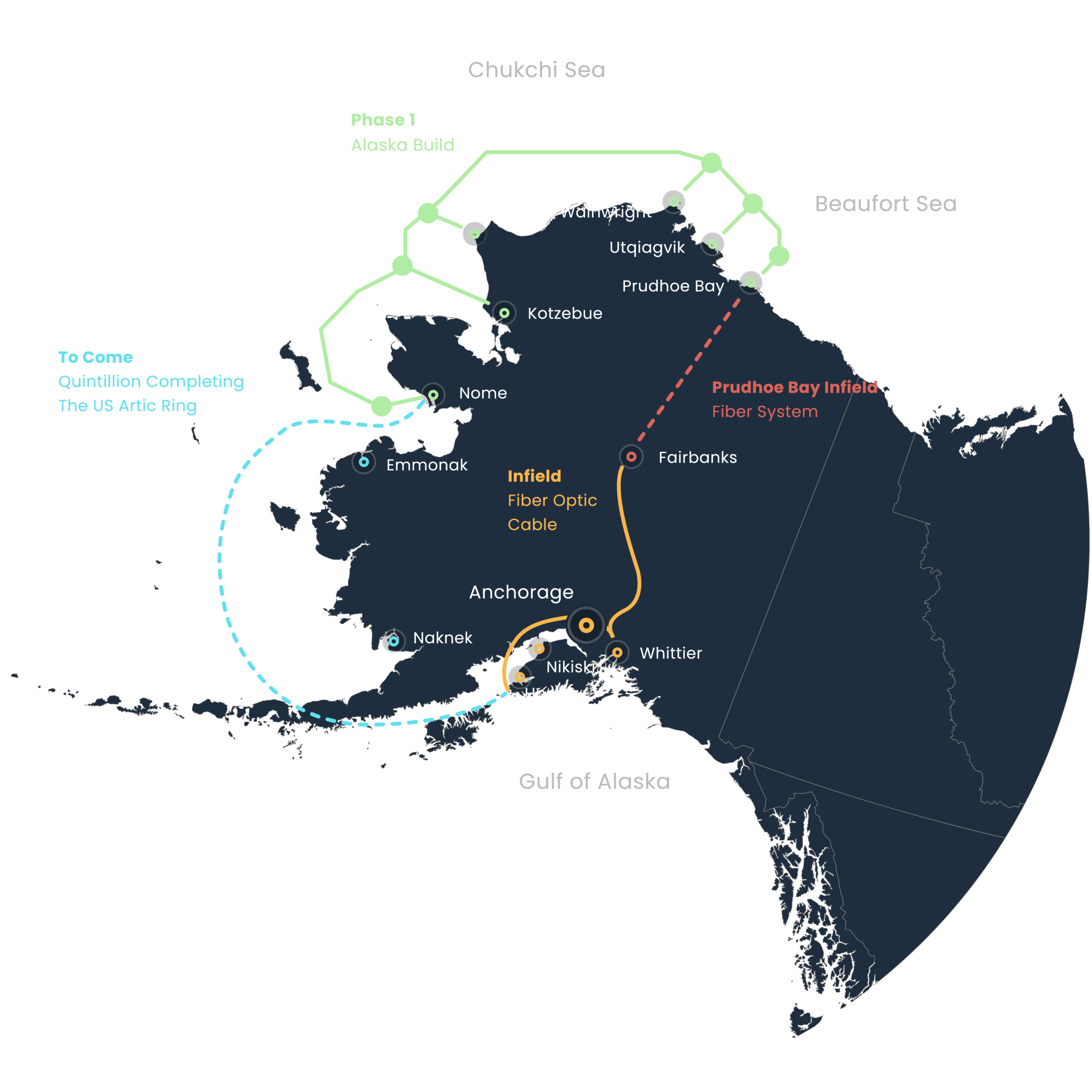
Pre-Deployment Planning

Comprehensive route confirmation, stakeholder engagement, and permit finalization ensure all technical, environmental, and operational criteria are met before deployment begins.

Early Works & Mobilization

Teams stage materials at Utqiaġvik and GMT2, prepare workforce housing, and establish logistics routes to support winter construction across the tundra.

Winter Construction Window

Over a 120-day winter season, crews surface-lay Arctic-hardened fiber, complete splicing segments, and install poles at select crossings as required.

System Testing & Commissioning

Following installation, engineers validate signal performance and activate redundancy mechanisms to complete the network loop supporting North Slope connectivity.

Technical Specifications

Network Infrastructure

Cable Type:

Arctic-hardened overland fiber cable

Fiber Pairs:

Connects to ConocoPhillips dark fiber at GMT2

Capacity:

2-mile design corridor/CWAT

Technology:

~171 miles of new terrestrial fiber

Resilience Features

Burial Depth:

2-3 meters

Armoring:

Double armor in shore zones

Redundancy:

Ring architecture

Monitoring:

24/7 NOC surveillance

The 171-mile Land Bridge route uses Arctic-hardened, surface-laid fiber installed during winter to protect permafrost, reduce environmental disturbance, and mirror proven regional deployments. Integrated with existing GMT2–Oliktok Point dark fiber, it strengthens backbone connectivity without extensive new excavation.

This terrestrial path creates essential redundancy when subsea routes fail, enhancing stability for healthcare, aviation, government operations, and public safety. Engineered for extreme Arctic conditions, it ensures reliable performance, reduced outage risks, and long-term resilience for North Slope communities.

Frequently Asked Questions

Why is the Land Bridge Project needed?
The repeated subsea cable breaks in 2023 and 2025 revealed a critical vulnerability in Arctic broadband. The Land Bridge Project creates a land-based, redundant path to Utqiaġvik, ensuring essential communications remain stable during coastal outages.
No. The design uses a surface-lay method on winter snow and ice, avoiding trenching that can accelerate permafrost thaw. This approach has been proven effective and environmentally stable in prior regional deployments.
Construction occurs during a 120-day winter window, when tundra travel is permitted and frozen conditions protect the landscape. Materials are staged in both Utqiaġvik and GMT2 to support the deployment schedule.
It provides a redundant terrestrial backup when subsea fiber is damaged. This redundancy helps maintain connectivity for healthcare, public safety, aviation systems, local government, and daily community operations.
Local ISPs will be able to connect through established handoff points within Quintillion’s existing North Slope network, once the terrestrial route between GMT2 and Utqiaġvik is active. The Land Bridge Project is designed to integrate directly into Quintillion’s broader backbone, creating a loop-redundant system that restores stability and increases available capacity. As with other Quintillion projects, ISPs can interconnect at designated network facilities to access transport services, backhaul capacity, and onward connectivity to Alaska and the Lower 48.
By restoring reliable connectivity to North Slope radar sites and defense infrastructure, the project strengthens situational awareness, early-warning systems, and communications continuity—while keeping national-security messaging limited in public-facing materials.

Want to Learn More?

Get in touch with our team to learn more about the Land Bridge Project and how it can serve your community or organization.